

Sean Donegan, CEO, Satelytics looks at how to protect your infrastructure.
Protecting any infrastructure is a complex task. A single point of failure can rapidly cascade into a total system shutdown. In 2019, a three-hour power outage across England and Wales affected 1.15 million customers and cost an estimated £15 million. Similarly, undetected faults result in unnecessary and costly waste. Water companies across the UK waste an average of 3 billion litres of water per day at a cost of £396 million per year. In 2023, UK energy producers lost about 232 kilotonnes of methane through leaks and venting, which harms the environment and adds to energy costs.
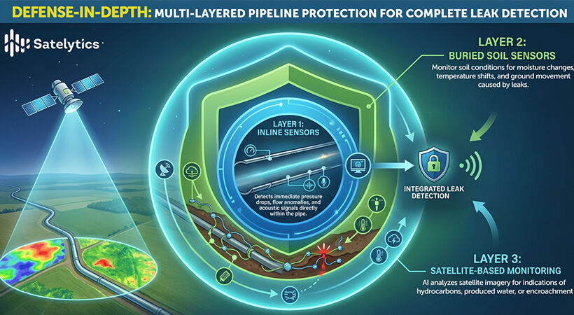
Reliance on a single monitoring system, whether ground-based sensors, site inspections, or aerial imagery, is inadequate when it comes to infrastructure protection. Multiple layers of monitoring are essential to uncover troublesome blind spots that can hide potential points of failure or weaknesses that can be exploited. A Defence-in-Depth strategy is needed.
Creating layers of protection - defence in depth
Defence-in-Depth was developed by the military, which recognised that no single defence measure is impregnable. Instead of concentrating all resources on a single weak point, you deploy layers of protection.
The concept is simple. When the first line of defence fails, a second layer of defence stops attackers before they can reach critical assets. The same principle can be applied in infrastructure monitoring, using complementary approaches to detect threats and mitigate failures.
Satellite imaging is ideal for a Defence-in-Depth strategy, especially when it means that massive damage can be the result of inadequate monitoring. Satellites provide a birds-eye view of the infrastructure from 270 miles up and can oversee 90% of the UK infrastructure. Not only do satellites provide more comprehensive monitoring, but satellite imaging is also more cost-effective than traditional methods. Satellites can cover vast areas, including challenging terrain, relying on complementary monitoring technologies to pinpoint problems identified by geospatial analytics.
Pinpointing problems with geospatial analytics
Advances in imaging technology and artificial intelligence (AI), and the explosive growth of commercial satellites, are revolutionising infrastructure monitoring. Images captured by low-orbiting commercial satellites can capture images with a resolution of 30-50 cm, about the size of a dinner plate. Remote sensing technology (RST) captures multispectral and hyperspectral imaging data from orbiting satellites. Spectral analysis can detect surface anomalies such as gas leaks, threats to power lines, new excavation and construction, and other surface activities that could pose a threat.
Speed matters when detecting infrastructure threats. Not only is analysis of satellite imaging more effective and less expensive than ground monitoring, but it’s also considerably faster. Traditional detection methods, such as site inspections, can take weeks or months. Using satellite images for geospatial analytics provides actionable intelligence in hours. Fast response times are crucial when dealing with methane leaks or pipeline integrity.
Geospatial analytics also enable precise response and resource allocation. Analysis of satellite imaging provides a macro view while highlighting the 5-10% of the infrastructure at greatest risk. Identifying problems with geospatial analytics isolates areas for ground-based investigation, making it easier to deploy teams of specialists where they can have the greatest impact.
Applying a Defence-in-Depth approach to infrastructure monitoring yields other benefits in addition to cost savings and faster response time:
- Fewer false positives – Traditional monitoring systems tend to generate false alarms that can consume 30% of operational teams’ time. When properly calibrated, AI-powered analysis of satellite imaging significantly reduces false positives by providing broader contextual data to differentiate real threats from benign anomalies.
- Better predictive capabilities – Effective infrastructure monitoring needs to be proactive rather than reactive. Geospatial analytics provides predictive data for proactive maintenance, thus reducing failures and extending the life of current assets.
- Scalable infrastructure coverage – Satellite imaging can scale to capture larger areas, decreasing costs per square mile, making geospatial analytics more economical for extensive infrastructures.
Examples of infrastructure defence-in-depth
To illustrate how Defence-in-Depth is applied in practice using geospatial analytics, consider the following real-world examples:
Measuring Methane Over Gas Distribution Networks: Methane measurement offers unique challenges that can be addressed using layers of detection.
Layer 1: Satellite monitoring – Satellite imaging can capture images across vast areas, detecting both large and small methane emissions. Broad-spectrum monitoring establishes a baseline that would be impossible to create using ground-based methods. Satellite technology has already proven invaluable for detecting methane leaks. Researchers at the University of Leeds studying methane emitters discovered a pipeline leak shedding 200 kg of methane per hour. One methane gas leak emitted as much as the annual electricity consumption of 7,500 homes.
Layer 2: Ground response – Using intelligence from satellite imaging, field teams can be dispatched with handheld “sniffers” to identify the source of methane leaks. Using a targeted approach increases efficiency while reducing operational costs.
Layer 3: Specialised coverage – In areas where satellite imagery may be restricted, such as military installations, Advanced Mobile Leak Detection (AMLD) can be dispatched to isolate leaks.
Applying a layered approach with complementary technologies delivers efficiencies and precision that no single solution can.
Vegetation management prevents outages
Overgrown vegetation and falling trees account for 20-50% of unplanned power outages, especially during severe storms and high winds. UK Power Networks, which maintains power cables in southeast and east England, spent £19 million on tree trimming in 2022, and plans to spend £90 million from 2023 to 2028. By adopting Defence-in-Depth, UK utilities are reducing costs and improving vegetation management efficiency.
Layer 1: Satellite monitoring – Geospatial analytics can show where vegetation and trees are encroaching on energy assets, highlighting areas that need immediate attention.
Layer 2: High-resolution ground truth – In High Consequence Areas (HCAs), where a failure could have a profound impact. LiDAR systems can provide effective positional monitoring, but multispectral image analysis can provide more precise information about trees and their health.
Layer 3: Predictive analytics – Integrating data sources improves vegetation management. Research shows that better vegetation management can reduce outages by as much as 30%.
Using satellite imaging and geospatial analytics to support Defence-in-Depth strategies provides layers of monitoring redundancy that are essential for protecting critical infrastructures. Each monitoring solution has strengths and weaknesses, with satellite technology providing comprehensive, cost-effective coverage and enabling rapid response. Using multiple monitoring systems, including a satellite umbrella, provides extensive visibility and protection that no single solution can offer.